
Louisiana Coastline Interactive Portal Project
In partnership with the Coastal Protection and Restoration Authority (CPRA) of Louisiana, PSC has developed an interactive public portal showing the Louisiana coastline as it is predicted to change over the next 50 years.
Seeing into the future
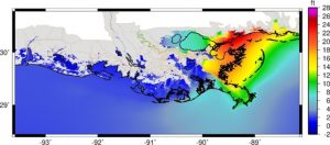
The team utilized PSC’s Bridges-2 (and before that, Bridges) to run simulations to assess the water landscape of Louisiana, taking advantage of the large storage capabilities of those systems. The data collected about the water basin included individual metrics such as area habitat, salinity, and water elevation, and risk-related factors like hurricanes, wave heights, flood depths, and storm events.
The data collected and run on the simulations also fed into a risk assessment, which informed the CPRA’s 2023 Master Plan, a vital document for state decision-making and funding allocations.
Enabling information-sharing
In order to translate the information collected into a publicly accessible format for lawmakers, decision-makers, and anyone interested in learning more about their local environment, CPRA turned to PSC staffers Juan Puerto and Matt Yoder to create the public portal on Bridges-2.
The portal is hosted on a virtual machine on Bridges-2, using the capacity of Bridges-2’s Ocean file system to avoid any massive data transfers from local drives. It is publicly accessible and interactive – visitors can see variables of the Louisiana water basin at its current state, and as it will evolve over the next 50 years, in 10 year increments.
- Flood Depth: Visitors can see the projected depth of flood waters for storms of different likelihoods (annual exceedance probabilities).
- Damage: Visitors can view projected storm damage, in dollars and number of structures damaged, by community.
- Projects: Visitors can explore the projects selected for inclusion in the Master Plan based on the model results.
.
This research was honored with the Editor’s Choice Award for Best Use of HPC in Response to Societal Plights, at the 2021 International Conference for High Performance Computing, Networking, Storage and Analysis (SC21).
You can read more about this work in our science highlight story: Hurricane Simulations by Bridges, Bridges-2 Inform State Decision-Making.
Thank you to the Coastal Protection and Restoration Authority of Louisiana for information contained in this article and for their continued partnership.