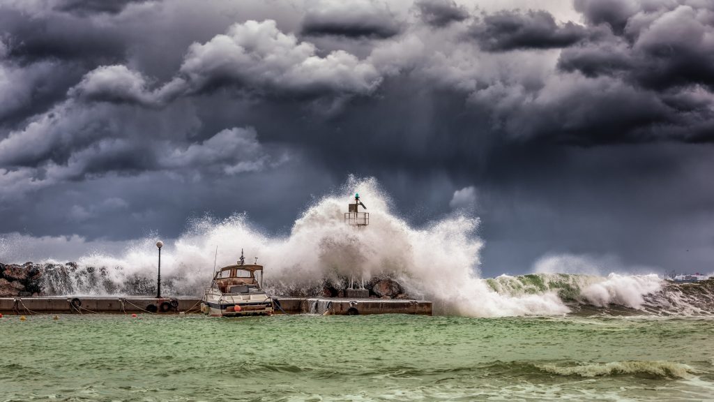
Big Waves Happen Here, Too
Bridges Simulations Chart Out Worst-Case Tsunami Scenarios for U.S. East Coast
Recent tsunamis have killed hundreds of thousands and done vast economic damage. But even areas not known for big waves, such as the East Coast of the U.S., are at risk. Working for the U.S. National Tsunami Hazard Mitigation Program, scientists at the universities of Rhode Island and Delaware have leveraged the large capacity and data analytics capabilities of PSC’s Bridges platform to simulate worst-case scenarios of tsunami damage on the eastern seaboard.
Why It’s Important
Tsunamis—sometimes mistakenly called “tidal waves”—have cast a big shadow in the 21st century. In 2004, the Boxing Day tsunami hit with the force of 23,000 Hiroshima bombs, killing nearly a quarter of a million people and inflicting devastating economic damage along the rim of the Indian Ocean. The citizens of Japan got somewhat more warning for the 2011 Tōhoku tsunami. But it still killed 19,000 people and caused ruinous meltdowns at the Fukushima Daiichi Nuclear Power Plant complex.
Many people are aware of the risk of tsunamis to the U.S. West Coast. Fewer realize that there’s risk on the East Coast as well. In 1929, an undersea landslide produced a tsunami that devastated coastal communities in Newfoundland, Canada, causing $5.6 million in damage in 2017 dollars. Worse, geologists see evidence of a prehistoric landslide tsunami that presumably caused damage from the Carolinas to Massachusetts, as recently as 16,000 years ago.
“After some major tsunamis that happened worldwide, such as the 2004 Indian Ocean tsunami, people woke up to the dangers that these events pose. Some places are really not prepared for them. On the West Coast we have a better idea of the risk because they’ve experienced tsunamis. But there’s also potential risk to the East Coast of the U.S., which is not well known. That risk is not zero.”—Lauren Schambach, University of Rhode Island
Working under the auspices of the National Oceanic and Atmospheric Administration’s National Tsunami Hazard Mitigation Program, Lauren Schambach, a graduate student at the University of Rhode Island, her advisor Stephan Grilli and their colleagues at the University of Delaware set out to simulate the impact to the U.S. East Coast if a landslide like the one 16,000 years ago were to happen today. They used PSC’s Bridges. The work is a continuation of research they began in 2010.
How PSC Helped
The University of Rhode Island team’s initial goal was to test the worst-case scenarios of the undersea landslide that triggered the prehistoric tsunami. To do this, they needed to vary the conditions of the landslide and to place it in different places off the East Coast. The calculations would have taken far too much time if carried out one after another. The power and number of Bridges’ general-purpose nodes (Bridges also features AI, GPU, and large-memory nodes) allowed them to test different scenarios at the same time. In addition, PSC’s mammoth parallel data storage system allowed them to store their data while still being able to retrieve it rapidly.
“Our local computers I’m using have about 56 cores available … They’re pretty good at setting up some preliminary simulations. In a case like this, we need many simulations testing different parameters. We need to be able to run lots of simulations … on lots of processors. On average it would take my computer about 12 hours to run a single simulation, on Bridges it would be less than 2 hours and I could do multiple [simulations] at the same time. So what used to take about a week on my own computer to do one ‘simulation case’ would be done in approximately half a day.”—Lauren Schambach, University of Rhode Island
The scientists’ simulations provided largely expected results, though researchers had not previously known the extent to which the different conditions would affect the resulting tsunamis. “Rigid slump” landslides, in which the sea bottom breaks off more or less as one piece, caused 50 percent more damage than “deforming slides,” which crumble as they move. Not surprisingly, landslides off heavily populated regions such as the Jersey Shore or Ocean City in Maryland could do a lot of damage.
An important variable was the roughness of the sea floor—sandy ocean beds led to less friction and more powerful waves; more common gravely bottoms tended to disperse the wave and cause less impact on the coast. Including such dispersion proved important, because dispersion caused short waves that travel with the main tsunami. The dispersion caused the second wave to hit the shore to be the most powerful, not the first. Also, the waves that followed the second wave were stronger than in the dispersion-free simulation. The team reported their results in the journal Pure and Applied Geophysics in July 2019.
The results further advance what will be a more complete study of tsunami risk on the East Coast. The July paper sketched out the biggest sources of risk. Future work will simulate more types of tsunami events, with the goal of increasing warning times and allowing coastal communities to upgrade building codes and safety procedures.