Virtual machines running on Bridges-2 and software developed by PSC enable on-demand functionality for real-time mapping, improved portal experience, and better quality control in the next version of Louisiana’s Coastal Master Plan.
PSC has long partnered with Louisiana’s Coastal Protection and Restoration Authority (CPRA) to help develop the state’s Coastal Master Plan, which is updated every 5–6 years. The plan involves simulating various environmental and engineering scenarios, such as sea-level rise and levee construction, to optimize coastal resilience. PSC supports this effort with its NSF-funded Bridges-2 system, and by developing software tools for internal quality control, public communication, and academic use.
WHY IT’S IMPORTANT
Louisiana has experienced severe coastal land loss—over 2,000 square miles since 1932. This has had a major impact on the state economically and environmentally. The team developed a public data viewer to visualize both past and projected future changes under different environmental conditions, illustrating the dire possibilities that could occur without intervention. The models developed by the team and the data produced can inform responses to land loss, vegetation change, and storm surge-based flooding based on project selection (i.e., choosing the optimal combination of interventions) and certainly has many applications.
A key focus of the project is technical innovation. Matt Yoder, PSC Senior Systems Software Engineer, works on the portals and other user-facing aspects of the project, as well as some of the underpinning technologies. Juan Muerto, PSC Principal Software Engineer, works on behind-the-scenes technologies that support quality assurance / quality control (QA/QC). In the past, the maps were pre-rendered and limited in scope. For the 2029 plan, which they are currently working on, the team is transitioning to real-time map rendering by improving data storage formats and leveraging indexing and compression. These updates will allow users to interactively view any variable the model produces, enhancing analytical power and flexibility.

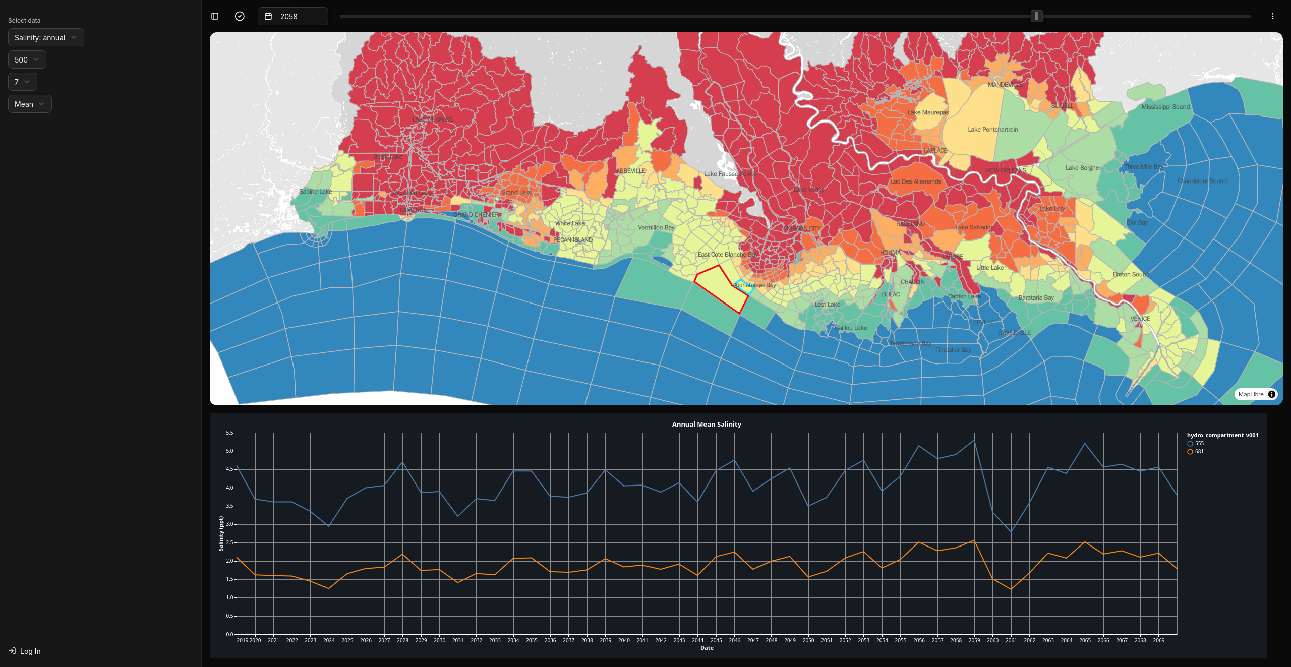
The Master Plan Data Portal shows mean annual salinity for coastal Louisiana. Salinity is one of the outputs from the Integrated Compartment Model, a suite of models run by the Coastal Protection and Restoration Authority on Bridges-2 to simulate landscape conditions under various environmental and project scenarios. Red areas have lower modeled salinity, while blue areas have higher modeled salinity.
“For the 2029 Master Plan, our focus has been on optimizing storage of model data and building software that enables real-time visualization of model results. We worked with our partners at CPRA to develop a plan that leverages Bridges-2’s compute and storage capabilities to streamline their workflows. As members of PSC’s Advanced Systems and Operations group, Juan and I are able to draw on our infrastructure expertise to build software that helps researchers get the most out of systems like Bridges-2.”
— Matt Yoder, PSC
HOW PSC HELPED
The powerful computing environment of Bridges-2, PSC’s flagship HPC platform, underpins this architecture by hosting the models, virtual machines, and data portals. Its support for persistent virtual machines is essential for running always-available applications.
Yoder described the ongoing development of a new portal that integrates data visualization with QA/QC tools. Users will be able to flag and discuss problems and inaccuracies in the model results directly within the application. This coordination is critical, as different modeling teams must sequentially run and validate their outputs.
“The QA/QC process involves multiple teams, across multiple institutions, which necessitates a robust and flexible software to manage. We’ve been able to work out the kinks since the first iteration of this project, and are integrating all of the different portals that we’ve created to optimize the process for this version of the project.”
— Juan Muerto, PSC
The project’s QA/QC approach is an iterative process where a suite of models for the plan runs sequentially. A big part of the effort is coordinating among all the different teams and making sure that everybody who needs to look at a set of model results has reviewed it and signed off before it goes to the next team to run their models and do their review.
Yoder also recently travelled to Louisiana to present at the State of the Coast conference, talking about the data structure work and how that supports the new visualizations that the PSC team is working on.
This complex, collaborative project combines high-performance computing, user-friendly visualization, and robust QA/QC processes to tackle one of Louisiana’s most urgent environmental challenges. Learn more at the 2029 Coastal Master Plan website.
